Where I'd live
Give every state or country one answer, from absolutely to never, and this where I'd live map maker shows the result three ways at once: a coloured map, a tier list of flags, and a ranked list you can reorder. Change an answer in any view and the other two follow. Export all three, or publish one page carrying them.
Also known as: where id live map, where i'd live, where would i live map, states i'd live in tier list, countries i'd live in.
Start a where I'd live map
The two big starts. For one country's regions or your own list of countries, use the chooser above the editor.
US and Canada
World and Regions
Popular completed where i would live maps
See all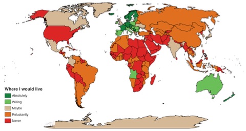
How to make a where I'd live
- Pick the part of the world. The four cards above the editor are the choices: the fifty US states, every country in the world, one country opened into its own regions, or a hand-picked list of countries. Anything else, a continent or a county map, is a Change map away once the editor is open.
- Answer on whichever view suits you. The Map tab paints a place with the answer you have armed. The Tier list tab drops flags into rows named after the answers. The Survey tab lists every place with a colour scale beside it: tap a label or a point on the bar. All three write the same answer, so pick the one that feels fastest and switch whenever you like.
- Put the answers in order. A category is a ranking, not just a colour. In the Survey tab drag a place up or down inside its answer, or tap further along the scale to land it lower in the section. The tier list shows the same order left to right, and the ranked list numbers every place from your first choice down.
- Rewrite the scale if five answers is the wrong number. Absolutely, Willing, Maybe, Reluctantly and Never open ready to use. Rename them, change their colours, delete the ones you do not need or add a sixth. Removing an answer sends its places back to the unranked pool rather than deleting them.
- Export the picture you want, or all three. The export dialog has a picker for the map, the tier list and the ranked list, and a Download all button that saves the three in turn. Publishing gives you one link whose preview is the map, with the tier list and the ranked list shown under it.
What you can do
- One answer per place, stored once and shown as a map, a tier list and a ranked list at the same time.
- Four ways in: US states, world countries, a single country with its subdivisions, or your own list of countries.
- A tier list whose bank holds every place on the map as a flag (states, countries) or an outline (everything else), placed by tap or by drag.
- A survey list with a colour-scale bar on every row, so a whole country can be answered without touching the map.
- Drag to reorder inside an answer, and a drop box on every other section to change the answer mid-drag.
- Answers survive a recolour, a renamed row and a change of base map, because they are keyed to the place, not the colour.
- Keyboard answers in the list: arrow keys to move, 1 to 9 for the answer, Delete to clear.
- Change map inside the editor for continents, counties and every other region set the map maker has.
- PNG export of any view, SVG and PDF of the map, and Download all for the set of three.
- Works on a phone, with the tier list in tap-to-place mode and the survey list built for a thumb.
Make your own where I'd live
The thread reply that needs a picture
Most where-would-you-live threads are answered with a map. This gives you the map and two more pictures from the same answers, so the reply can carry the coloured map and the tier list of flags, which reads instantly in a feed.
A country you know well, region by region
Open Spain, Japan or Australia into its own regions and answer each one. The outline tiles in the tier list make the parts you would never move to as visible as the ones you would, and the ranked list settles which region is first.
Shortlisting a move for real
Use the survey list on its own: work down every place, tap the scale, then drag the few serious candidates into order at the top of Absolutely. The map at the end shows whether your shortlist is a region or a scatter.
Two lists, one argument
Each person makes their own with the same five answers, then compare the ranked lists side by side. The tier list makes agreement and disagreement obvious per flag in a way two maps do not.
Any set of countries you care about
Pick the EU members, the countries you have citizenship options in, or the places a visa would let you work, and answer just those. The custom selection card takes any list, with or without subdivisions.
Common questions
What is the difference between this and the map-only page?
The map-only page paints a US map and stops there. This editor stores one answer per place and draws it three ways: the same map, a tier list with a row per answer, and a ranked list with an order inside every answer. If you only want the map, either page works; if you want the flags in rows or a numbered ranking, use this one.
Do I have to fill in all three views?
No. They are three views of one set of answers. Painting a state on the map puts it in that row of the tier list and that section of the ranked list at once, and moving a flag in the tier list recolours the map. Use whichever view is quickest and ignore the others until export.
Where do the flags come from?
US states and world countries use the bundled flag packs. Anything without a flag in those packs, such as a French department or a Japanese prefecture, is shown as its outline instead, drawn from the same map data. Both work in the tier list, in the export and on the published page.
Can I change the answers or their colours?
Yes. The five that open are the ones the r/whereidlive threads use, but every row can be renamed and recoloured, rows can be added, deleted and reordered. Recolouring an answer repaints every place that has it, and the places keep their order.
How does the ranking inside an answer work?
Every place carries a position inside its answer. On the survey list, drag a row to reorder it, or tap near the top of the scale segment to land high and near the bottom to land low. The tier list reads the same order left to right, and the ranked list numbers the places 1, 2, 3 across the answers from the top row down.
What does the export give me?
Any of the three pictures on its own, or all three with Download all. The map can also be saved as SVG or PDF. Publishing uploads the map as the page image and renders the tier list and the ranked list under it on the same page, so one link shows the full answer.
Can I start from a continent or a county map?
The four cards on this page cover the common starts. For everything else, open the editor on any of them and use Change map, which offers every map the map maker has, from continents to US counties. Your answers stay with the places whose codes the new map still draws.
Is it free, and do I need an account?
Making, exporting and downloading are free with no login; the document stays in your browser until you choose to publish. Publishing needs an account because it creates a public page with your name on it.